
There are many interesting facts to unpack from this excellent map by Chris Brackley, cartographer for Canadian Geographic.
 The map was featured in the March/April 2017 issue and on their best maps of 2017 page. It accompanied an essay detailing the history of claims in the Arctic region. The exclusive economic zones (200 nautical miles offshore) are shown for Canada, the United States, Russia, Norway, Iceland and Denmark. It also shows the huge amount of sea ice lost since 1974.
Four north poles are shown. There is the geographic pole (the center of rotation and northernmost point where longitude lines converge) and the magnetic north pole, where magnetic needles become vertical. There is also a Geomagnetic North Pole. This is where magnetic north would be, if the earth's magnetic field was a straight line from the core to the surface of the planet. Instead magnetic poles are driven by convection currents within the earth's molten iron core. Magnetic poles wander more than geomagnetic poles. The movements of both poles since 1900 are shown on the map above. The best explanation I have found for the difference between Magnetic North and Geomagnetic North is on this page from StackExchange, and includes this cool yarnball of a diagram.
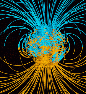 The blue lines point towards the earth's core, while yellow lines point away.
The fourth pole is the pole of inaccessibility. This the most difficult to reach point. In this region it refers to the spot in the Arctic Ocean furthest from land.
 Remember back in the early 1990's when you could reach Magnetic North by land? Those were good times!

Four north poles are shown. There is the geographic pole (the center of rotation and northernmost point where longitude lines converge) and the magnetic north pole, where magnetic needles become vertical. There is also a Geomagnetic North Pole. This is where magnetic north would be, if the earth's magnetic field was a straight line from the core to the surface of the planet. Instead magnetic poles are driven by convection currents within the earth's molten iron core. Magnetic poles wander more than geomagnetic poles. The movements of both poles since 1900 are shown on the map above. The best explanation I have found for the difference between Magnetic North and Geomagnetic North is on this page from StackExchange, and includes this cool yarnball of a diagram.

The fourth pole is the pole of inaccessibility. This the most difficult to reach point. In this region it refers to the spot in the Arctic Ocean furthest from land.


1 comment:
Super helpful, thank you!
Post a Comment